Nombre total de pages vues

Affichage des articles dont le libellé est #Greece. Afficher tous les articles

dimanche 2 août 2026

Greece - Wider Area of Mount Olympus


1913


1973


1999


2013


Greece – Wider Area of Mount Olympus

Mount Olympus is situated in northern Greece and is the highest mountain in the country. Its microclimate, resulting from its proximity to the sea and abrupt elevation, produces a remarkable diversity in terrain, climate, and vegetation. In this landscape, the ancient Greeks situated the abode of their Twelve Olympian Gods, with Zeus as their sovereign, as well as the Muses and Graces. Through the writings of Hesiod and Homer, Mount Olympus became a central point of reference for Greek mythology throughout the Greek and Roman worlds, rendering Mount Olympus an enduring emblem of Greek civilisation. The property features striking landforms, including glacial cirques, limestone cliffs, karstic sinkholes, and olistolith fields, while sharp ridges like the Mytikas-Stefani complex and deep gorges such as the Enipeas illustrate ongoing neotectonic activity. Mount Olympus has served as a glacial refugium for forest species and is also a Mediterranean plant biodiversity and endemism hotspot.

Grèce – Mont Olympe et son environnement

Le mont Olympe est situé dans le nord de la Grèce et constitue la plus haute montagne du pays. Son microclimat, résultant de sa proximité avec la mer et de son élévation abrupte, produit une diversité remarquable de terrains, de climats et de végétation. Dans ce paysage, les anciens Grecs situaient la demeure de leurs Douze Dieux Olympiens, avec Zeus comme souverain, ainsi que des Muses et des Grâces. Grâce aux écrits d'Hésiode et d'Homère, le mont Olympe devint un point de référence central pour la mythologie grecque à travers les mondes grec et romain, faisant du mont Olympe un emblème durable de la civilisation grecque. Le site présente des reliefs remarquables, notamment des cirques glaciaires, des falaises calcaires, des dolines karstiques et des champs d'olistolithes, tandis que des crêtes abruptes comme le complexe Mytikas-Stefani et des gorges profondes comme les Enipeas illustrent une activité néotectonique en cours. Le mont Olympe a servi de refuge glaciaire pour les espèces forestières et constitue également un point chaud de biodiversité végétale méditerranéenne et d'endémisme.

Grecia – Monte Olimpo y su entorno

El Monte Olimpo está situado en el norte de Grecia y es la montaña más alta del país. Su microclima, fruto de la proximidad del mar y de su abrupta elevación, produce una notable diversidad del terreno, del clima y la vegetación. Los antiguos griegos situaron en este lugar la morada de sus Doce Dioses del Olimpo, con Zeus como su soberano, así como de las Musas y las Gracias. Las obras de Hesíodo y Homero convirtieron el Monte Olimpo en un punto de referencia central para la mitología en las culturas griega y romana y en un emblema perdurable de la civilización griega. El bien cuenta con impresionantes paisajes que incluyen circos glaciales, acantilados de piedra caliza, sumideros kársticos y campos de olistolitos, mientras que crestas abruptas como el complejo Mytikas-Stefani y profundas gargantas como el Enipeas ilustran la actividad neotectónica actual. El Monte Olimpo ha servido como refugio glaciar para especies forestales y también es un punto crítico de biodiversidad vegetal mediterránea y de endemismo.

Griechenland – Weitere Umgebung des Olymp

Olymp liegt im Norden Griechenlands und ist der höchste Berg des Landes. Das Mikroklima, die Folge seiner Lage in der Nähe des Meers und seiner steilen Erhebung, hat eine bemerkenswerte Vielfalt von Geländen, Klimas und Vegetation erschafft. Die alten Griechen betrachteten diese Landschaft als die Residenz der Zwölf Olympische Götter, mit Zeus als Herrscher, sowie der Musen und der Chariten. Dank den Schriften Hesiods und Homers wurde der Olymp zu einem zentralen Bezugspunkt für die griechische Mythologie in der griechischen und römischen Welt, die ein nachhaltiges Sinnbild der griechischen Zivilisation aus dem Olymp machten. Die Stätte zeigt bemerkenswerte Reliefs, darunter Eisfelsenkessel, Kalksteinfelswände, Karstdolinen und Olistolithfelder, während steile Grate wie der Mytikas-Stefani und tiefe Schluchten wie Epineas eine neotektonische Tätigkeit im Gange veranschaulichen. Der Olymp dient als Gletscherlebensraum für die Waldarten und bildet auch ein Hotspot für die mittelländischen Biodiversität und Endemismus.

اليونان - المنطقة الأوسع لجبل أوليمبوس

يقع جبل أوليمبوس في شمال اليونان، وهو أشمُّ جبالها وأعلاها ذروة. وقد خصّته الطبيعة، بما اجتمع فيه من قرب من البحر وسموّ في الارتفاع، بتنوع بديع في تضاريسه وتباين في مناخه وغنى وافر في غطائه النباتي. واتخذ الإغريق القدماء من هذا المنظر الطبيعي مقراً لآلهتهم الأولمبية الاثني عشر، وفي مقدمتهم زيوس، كبير الآلهة عندهم، ومعه إلهات الفنون والجمال. ثم ما لبث، بما دوّنه هسيود وهوميروس، أن غدا قطباً تدور عليه الميثولوجيا اليونانية في أنحاء العالمين اليوناني والروماني، ما جعله رمزاً خالداً من رموز الحضارة اليونانية. ويضم الموقع تكوينات جيولوجية لافتة، منها الأحواض الجليدية، والمنحدرات الكلسية، والحفر الكارستية، وحقول الكتل الصخرية المنقولة (الأوليستوليثات)، فيما تشهد الحواف الجبلية الحادة، مثل مجمع ميتكاس–ستيفاني، والأودية السحيقة، مثل وادي إنيبياس، على استمرار النشاط التكتوني الحديث. وقد كان جبل أوليمبوس ملاذاً جليدياً حافظ على أنواع الغابات خلال العصور الجليدية، كما يُعتبر مركزاً مهماً للتنوع النباتي والتوطن النباتي في منطقة البحر الأبيض المتوسط.

希腊 -奥林匹斯山及周边区域

奥林匹斯山位于希腊北部,是该国最高峰。由于毗邻海洋且地势陡峭抬升,其独特小气候造就了极丰富的地形、气候和植被类型。古希腊人视这里为神之居所,包括以宙斯为首的12位奥林匹斯主神,以及缪斯女神和美惠三女神。赫西俄德和荷马的著作使奥林匹斯山成为整个希腊和罗马世界中希腊神话体系的核心参照,并成为希腊文明的恒久象征。遗产拥有壮观的自然地貌,包括冰川圈谷、石灰岩峭壁、岩溶塌陷和滑塌岩体区;米蒂卡斯—斯蒂法尼(Mytikas–Stefani)山脊群等陡峭山脊以及埃尼佩阿斯(Enipeas)等深谷,则展现了持续的新构造运动。奥林匹斯山曾是森林物种的冰期避难所,同时也是地中海地区植物多样性和特有植物的热点地区。

Греция – Район горы Олимп

Гора Олимп расположена на севере Греции и является самой высокой горой страны. Благодаря близости к морю и резкому перепаду высот здесь сформировался особый микроклимат, обусловивший исключительное разнообразие рельефа, климата и растительности. Именно здесь, согласно представлениям древних греков, находилась обитель двенадцати олимпийских богов во главе с Зевсом, а также место пребывания Муз и Харит. Благодаря произведениям Гесиода и Гомера гора Олимп стала одним из центральных образов греческой мифологии во всём греко-римском мире и превратилась в символ греческой цивилизации. Объект включает впечатляющие формы рельефа — ледниковые кары, известняковые скалы, карстовые воронки и поля олистолитов. Острые гребни, такие как комплекс Митикас-Стефани, и глубокие ущелья, включая Энипеас, свидетельствуют о продолжающейся неотектонической активности. Гора Олимп также была ледниковым рефугиумом для лесных видов и остается важным центром растительного биоразнообразия и эндемизма в Средиземноморье.

ギリシャ – オリンポス山の広い地域

オリンポス山はギリシャ北部に位置し、国内で最も高い山です。海に近いことと急激な標高による微気候は、地形、気候、植生において驚くべき多様性を生み出しています。この風景の中で、古代ギリシャ人はゼウスを主権者とする十二のオリンポスの神々の住まいと、ミューズや美女たちの住まいを配置しました。ヘシオドスやホメロスの著作を通じて、オリンポス山はギリシャ・ローマ世界全体でギリシャ神話の中心的な基準となり、ギリシャ文明の永続的な象徴となっています。この土地には氷河の円谷、石灰岩の崖、カルスト陥没穴、オリストリスの地帯などの印象的な地形があり、ミティカス・ステファニ複合体のような鋭い尾根やエニペアスのような深い峡谷は進行中の新構造活動を示しています。オリンポス山は森林種の氷河の避難所として機能し、地中海植物の生物多様性や固有種のホットスポットでもあります。

Griekenland – Breder gebied van de berg Olympus

De berg Olympus ligt in het noorden van Griekenland en is de hoogste berg van het land. Het microklimaat, als gevolg van de nabijheid van de zee en de abrupte hoogte, zorgt voor een opmerkelijke diversiteit aan terrein, klimaat en vegetatie. In dit landschap vestigden de oude Grieken de woning van hun Twaalf Olympische Goden, met Zeus als hun soeverein, evenals de Muzen en Genaden. Door de geschriften van Hesiodus en Homerus werd de berg Olympus een centraal referentiepunt voor de Griekse mythologie in de Griekse en Romeinse wereld, waardoor de berg Olympus een blijvend symbool van de Griekse beschaving werd. Het terrein heeft opvallende landvormen, waaronder gletsjercirques, kalkstenen kliffen, karstzinkgaten en olistolietvelden, terwijl scherpe ruggen zoals het Mytikas-Stefani-complex en diepe kloven zoals de Enipeas voortdurende neotektonische activiteit illustreren. De berg Olympus heeft gediend als een gletsjerrefugium voor bossoorten en is ook een hotspot voor mediterrane plantendiversiteit en endemisme.


dimanche 13 juillet 2025

Greece - Minoan Palatial Centres


Crete 1905
Crète 1905
Creta 1905
Kreta 1905


Greece 1937
Grèce 1937
Grecia 1937
Griechenland 1937


Greece 1961
Grèce 1961
Grecia 1961
Griechenland 1961


Greece 1961
Grèce 1961
Grecia 1961
Griechenland 1961


Greece 2019
Grèce 2019
Grecia 2019
Griechenland 2019


Greece 2025
Grèce 2025
Grecia 2025
Griechenland 2025


Greece – Minoan Palatial Centres

This serial property comprises six archaeological sites on Crete dating from 1900 to 1100 BCE. These sites represent the Minoan civilization, a major prehistoric Mediterranean culture. The palatial centres served as administrative, economic, and religious hubs, featuring advanced architecture, urban planning, and vibrant frescoes. They reveal early writing systems, maritime networks, and cultural exchanges. The property highlights the complexity of the Minoans’ social structure and their enduring influence on Mediterranean history.

Grèce – Centres palatiaux minoens

Ce bien en série comprend six sites archéologiques situés en Crète, datant de 1 900 à 1 100 avant notre ère. Ces sites illustrent la civilisation minoenne, une importance société préhistorique de la Méditerranée. Les centres palatiaux remplissaient des fonctions administratives, économiques et religieuses, caractérisés par une architecture poussée, un urbanisme complexe et des fresques colorées. Ils révèlent des systèmes d’écriture précoces, des réseaux maritimes, des échanges culturels et mettent en évidence la sophistication de la société minoenne et son influence durable sur l’histoire méditerranéenne.

Grecia – Centros palaciegos minoicos

Situados en un remoto paisaje rural del noroeste de Grecia, los pequeños pueblos de piedra conocidos como Zagorochoria se extienden a lo largo de las laderas occidentales de la parte septentrional de la cordillera del Pindo. Estos pueblos tradicionales, típicamente organizados en torno a una plaza central que contiene un plátano y rodeados de bosques sagrados mantenidos por las comunidades locales, muestran una arquitectura tradicional adaptada a la topografía montañosa. Los pueblos se conectaban a través de una red de puentes con arcos de piedra, caminos empedrados y escaleras de piedra, creando así un sistema que funcionaba como una unidad política y social, uniendo a las comunidades de la cuenca del río Voïdomatis.

Griechenland – Minoische Palastzentren

Diese Stätte umfasst sechs archäologische Stätten auf Kreta, die von den Jahren 1900 bis zu 1100 bevor Christus datieren. Diese Stätten zeugen von der minoischen Zivilisation, eine wichtige prähistorische Gesellschaft am Mittelmeer. Die Palastzentren erfüllten administrative, wirtschaftliche und religiöse Funktionen und waren von ihrer hochentwickelten Architektur, ihrer komplexen Stadtplanung und ihren bunten Fresken kennzeichnet. Sie zeigen frühe Schriftsysteme, maritime Netze, kulturelle Austausche und zeugen von dem hohen Entwicklungsstand der minoischen Gesellschaft und ihrem langen Einfluss auf der Geschichte der Mittelmeervölker.

 اليونان - مراكز مينوان بالاتيك

 يضم هذا العنصر المتسلسل ستة مواقع أثرية في جزيرة كريت يعود تاريخها إلى الفترة الممتدة من عام 1900 إلى 1100 قبل الميلاد. وتمثّل هذه المواقع الحضارة المينوسية التي تندرج في عداد أبرز ثقافات عصر ما قبل التاريخ في منطقة البحر الأبيض المتوسط. كانت هذه المراكز المهيبة محاور إدارية واقتصادية ودينية، وتميّزت بهندستها المعمارية المتقدّمة وتخطيطها الحضري ولوحاتها الجدارية النابضة بالحياة. وتكشف هذه المراكز أيضاً نظم الكتابة القديمة والشبكات البحرية والتبادلات الثقافية. وتُبرز هذه المراكز أيضاً مدى تعقيد البنية الاجتماعية المينوسية وتأثيرها العميق والمستمر في تاريخ منطقة البحر الأبيض المتوسط..

希腊 – 米诺斯教皇中心

该系列财产包括位于克里特岛的六个考古遗址,其历史可追溯到公元前 1,900 年至公元前 1,100 年。这些遗址展示了米诺斯文明,这是地中海重要的史前社会。富丽堂皇的中心履行了行政、经济和宗教功能,其特点是广泛的建筑、复杂的城市规划和色彩缤纷的壁画。它们揭示了早期的书写系统、海上网络、文化交流,并突出了米诺斯社会的复杂性及其对地中海历史的持久影响。

Греция – минойские дворцовые центры

Этот серийный объект включает в себя шесть археологических памятников, расположенных на Крите, датируемых от 1900 до 1100 лет до нашей эры. Эти объекты иллюстрируют минойскую цивилизацию, важное доисторическое общество в Средиземноморье. Дворцовые центры выполняли административные, экономические и религиозные функции, характеризуясь обширной архитектурой, сложным градостроительством и красочными фресками. Они раскрывают ранние системы письменности, морские сети, культурные обмены, а также подчеркивают сложность минойского общества и его длительное влияние на историю Средиземноморья.

ギリシャ – ミノアのパラティックセンター

このシリアルプロパティは、紀元前1,900年から1,100年までのクレタ島にある6つの遺跡で構成されています。これらの遺跡は、地中海の重要な先史時代の社会であるミノア文明を示しています。宮殿のような中心部は、大規模な建築、複雑な都市計画、カラフルなフレスコ画を特徴とする行政、経済、宗教の機能を果たしました。それらは、初期の書記体系、海事ネットワーク、文化交流を明らかにし、ミノア社会の洗練と地中海の歴史への永続的な影響を強調しています。

Griekenland – Minoïsche Paltische Kreta

Dit seriële eigendom bestaat uit zes archeologische vindplaatsen op Kreta, daterend uit 1.900 tot 1.100 v.Chr. Deze sites illustreren de Minoïsche beschaving, een belangrijke prehistorische samenleving in het Middellandse Zeegebied. De vorstelijke centra vervulden administratieve, economische en religieuze functies en werden gekenmerkt door een uitgebreide architectuur, complexe stedenbouw en kleurrijke fresco's. Ze onthullen vroege schrijfsystemen, maritieme netwerken, culturele uitwisselingen en belichten de verfijning van de Minoïsche samenleving en haar blijvende invloed op de mediterrane geschiedenis.


mercredi 4 octobre 2023

Greece - Zagori Cultural Landscape


1942


1980


1981


1997


Greece – Zagori Cultural Landscape

Located in a remote rural landscape in northwestern Greece, small stone villages known as Zagorochoria extend along the western slopes of the northern part of the Pindus mountain range. These traditional villages, typically organized around a central square containing a plane tree and surrounded by sacred forests maintained by local communities, showcase a traditional architecture adapted to the mountain topography. A network of stone-arched bridges, stone cobbled paths, and stone staircases linking the villages formed a system that served as a political and social unit connecting the communities of the Voïdomatis River basin.

Grèce – Paysage culturel de Zagori

Situé dans un paysage rural reculé au nord-ouest de la Grèce, des petits villages en pierre connus sous le nom de Zagorochoria s’étendent le long du versant occidental de la partie septentrionale du massif montagneux du Pinde. Ces villages traditionnels, généralement organisés autour d’une place centrale sur laquelle se dresse un platane, et entourés de forêts sacrées entretenues par les communautés locales, présentent une architecture traditionnelle adaptée à la topographie des montagnes. Un ensemble de ponts en arc, de chemins pavés et d'escaliers, tous en pierre, reliait les villages et formait un réseau assurant l'unité politique et sociale des communautés du bassin de la rivière Voïdomatis.

Grecia – Paisaje cultural de Zagori

Situados en un remoto paisaje rural del noroeste de Grecia, los pequeños pueblos de piedra conocidos como Zagorochoria se extienden a lo largo de las laderas occidentales de la parte septentrional de la cordillera del Pindo. Estos pueblos tradicionales, típicamente organizados en torno a una plaza central que contiene un plátano y rodeados de bosques sagrados mantenidos por las comunidades locales, muestran una arquitectura tradicional adaptada a la topografía montañosa. Los pueblos se conectaban a través de una red de puentes con arcos de piedra, caminos empedrados y escaleras de piedra, creando así un sistema que funcionaba como una unidad política y social, uniendo a las comunidades de la cuenca del río Voïdomatis.

Griechenland – Kulturlandschaft Zagori

In einer entlegenen ländlichen Landschaft im Nordwesten Griechenlands liegen kleine Steindörfer, die Zagorochoria benannt sind, entlang des westlichen Hangs des nördlichen Gebiets des Pindos-Gebirges. Diese traditionellen Dörfer sind im Allgemeinen um einen zentralen Platz geplant worden, auf welchem eine Platane steht und zeigen eine traditionelle Architektur, die an die Topografie der Berge angepasst ist. Sie sind von heiligen Wäldern umgeben, die von den lokalen Gemeinschaften gepflegt sind. Eine Reihe von bogenförmigen Brücken, gepflasterten Wegen und Treppen, die alle aus Stein gebaut worden sind, verband die Dörfer und bildete ein Netz, das die politische und soziale Einheit der Gemeinschaften des Beckens des Flusses Voïdomatis sicherte.

منظر زاجوري الثقافي

تقع القرى الحجرية الصغيرة المعروفة باسم "زاجوروشوريا" في منطقة ريفية نائية في شمال غرب اليونان، وتمتد على طول المنحدرات الغربية للجزء الشمالي من سلسلة جبال بيندوس. تُشيّد هذه القرى التقليدية عادة حول ساحة مركزية فيها شجرة دلب وتحيط بها غابات مقدسة تحافظ عليها المجتمعات المحلية، وتتميز بعمارة تقليدية تتلاءم مع تضاريس الجبال.وشكلت شبكة من الجسور الحجرية المقوسة، والممرات المرصوفة بالحصى، والسلالم الحجرية التي تربط القرى، نظاماً كان بمنزلة وحدة سياسية واجتماعية تربط مجتمعات حوض نهر فويدوماتيس.

Культурный ландшафт Загори

Небольшие каменные деревни, известные как Загорохория, расположены в отдаленных сельских районах на северо-западе Греции и тянутся вдоль западных склонов северной части горного массива Пинд. Эти традиционные деревни, расположенные вокруг центральной площади с платаном и окруженные священными лесами, поддерживаемыми местными общинами, демонстрируют традиционную архитектуру, адаптированную к горному рельефу. Сеть каменных мостов, мощеных дорожек и каменных лестниц, соединяющих деревни, образует систему, которая служит политической и социальной единицей, связывающей сообщества бассейна реки Войдоматис.


dimanche 26 avril 2020

Greece - Medieval City of Rhodes


1961


1989


1993


2006


2019


2022


2022


Greece - Medieval City of Rhodes

The Knightly Order of St John of Jerusalem occupied the city from 1309 to 1523 and set about transforming the city into a stronghold. It was subsequently under Turkish and Italian rule. Its Upper Town is one of the most beautiful urban ensembles of the Gothic period, with its Palace of the Grand Masters, the Great Hospital and the Street of the Knights. In the Lower Town the Gothic architecture co-exists with mosques, public baths and other buildings built during the Ottoman period.

Grèce - Ville médiévale de Rhodes

L'Ordre des Hospitaliers de Saint-Jean-de-Jérusalem a occupé la ville de 1309 à 1523 et a entrepris de la transformer en place forte avant qu'elle ne passe successivement sous domination turque et italienne. La haute-ville est l'un des plus beaux ensembles urbains de la période gothique, avec le Palais des grands maîtres, l'Hôpital et la rue des Chevaliers. Dans la basse-ville, l'architecture gothique coexiste avec des mosquées, des bains publics et d'autres édifices construits durant la période ottomane.

Grecia - Ciudad medieval de Rodas

La Orden Militar y Hospitalaria de San Juan de Jerusalén ocupo esta ciudad desde 1309 hasta 1523, dedicándose a convertirla en una plaza fuerte. Posteriormente, la ciudad paso a manos de los turcos y los italianos sucesivamente. El Palacio de los Grandes Maestres, el Gran Hospital y la calle de los Caballeros hacen de la ciudad alta uno de los más hermosos conjuntos urbanos la arquitectura gótica. En la ciudad baja este estilo arquitectónico coexiste el de las mezquitas, baños de vapor públicos y otros edificios que datan del periodo de la dominación otomana.

Griechenland - Mittelalterliche Stadt Rhodos

Der Johanniterorden von Jerusalem hat die Stadt zwischen den Jahren 1309 und 1523 besetzt und hat unternommen, sie in einen befestigten Ort zu verwandeln, bevor sie von den Türken und den Italienern nacheinander beherrscht wurde. Die Hochstadt mit dem Palast der Großmeister, dem Hospital und die Rittenstraße ist einer der schönsten Stadtkomplexe der gotischen Epoche. In der Unterstadt koexistiert die gotische Architektur mit Moscheen, Bädern und anderen Gebäuden, die in der ottomanischen Epoche gebaut wurden.


jeudi 23 avril 2020

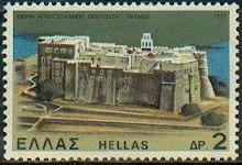
Greece - The Historic Centre (Chora) with the Monastery of Saint John "The Theologian" and the Cave of the Apocalypse on the Island of Patmos


1972


1972


1994


2022


Greece - The Historic Centre (Chora) with the Monastery of Saint John "The Theologian" and the Cave of the Apocalypse on the Island of Patmos

The small island of Patmos in the Dodecanese is reputed to be where St John the Theologian wrote both his Gospel and the Apocalypse. A monastery dedicated to the "Beloved Disciple" was founded there in the late 10th century and it has been a place of pilgrimage and of Greek Orthodox learning continuously since that time. The fine monastic complex dominates the island, and the old settlement of Chora associated with it, which contains many religious and secular buildings.

Grèce - Centre historique (Chora) avec le Monastère de Saint-Jean "le Théologien" et Grotte de l'Apocalypse sur l'Ile de Patmos

La petite île de Patmos, dans le Dodécanèse, est réputée être l'endroit ou Saint Jean le théologien a écrit son Évangile et l'Apocalypse. Un monastère dédié au "disciple bien aimé" y a été fonde à la fin du Xe siècle. Il est depuis cette époque un lieu de pèlerinage et d'enseignement orthodoxe grec permanent. Ce magnifique complexe monastique domine l'île et l'ancien établissement de Chora, qui lui est associé, abrite de nombreux édifices religieux et séculiers.

Grecia - Centro histórico (Chora) con el Monasterio de San Juan "El Teólogo" y la Gruta de la Apocalipsis sobre la isla de Patmos

Situada en el archipiélago del Dodecaneso, la pequeña isla de Patmos es celebre por ser el lugar donde San Juan el Teólogo escribió su Evangelio y el Apocalipsis. A finales del siglo X se fundó en la isla un monasterio dedicado al discípulo bien amado, que se convirtió en lugar de peregrinación y centro de enseñanza de la Iglesia Ortodoxa griega. Este magnífico conjunto monástico domina la isla, mientras que el antiguo y vecino asentamiento humano de Chora cuenta con numerosos edificios religiosos y civiles.

Griechenland - Historische Altstadt (Chora) mit dem Kloster von Sankt Johannes "dem Theologen" und der Höhle der Apokalypse auf der Insel Patmos

Die kleine Insel Patmos in Dodekanes ist als der Ort bekannt, wo Sankt Johannes der Theologe sein Evangelium und die Apokalypse schrieb. Ein dem "geliebten Anhänger" geweihte Kloster wurde in Patmos am Ende des 10ten Jahrhunderts gebaut. Seit dieser Zeit ist er ein ständiger griechischer und orthodoxer Pilger- und Lehreort. Dieses wunderschone Kloster überragt die Insel und die Altstadt Chora, die in der Nähe sich befindet, enthält zahlreiche religiöse und weltliche Bauwerke.